Monday, July 29, 2013

Copper City Washington Ghost Town and Mill Site


Last week, I had a spare day to get out and about. My Grandson Darien and I took a trip over Chinook Pass to find the ghost town of Copper City. The U.S. Forest Service is talking about bulldozing the mill site, so I wanted to see the site and ore piles before that happened.

FS Road 1808 has been closed at the Mt. Aix trailhead since 2006 flooding and bridge washouts by Deep Creek until just recently. The trip to this site was a long 4.8 mile hike one way. Now it's only 1.5 miles because one of the bridges has been repaired. There is still road damage along the last 1.5 miles of roadway to the town site.

The directions to the site are as follows:
Coming from the west on Highway 410, travel approximately 35.6 miles from Chinook Pass to Bumping River Road/National Forest Road 1800. Turn right (south) onto this road. Drive 13.5 miles past Goose Prairie and Bumping Lake and keep left at the intersection, turning onto Forest Service road 1808 following Deep Creek. Continue on this road for approximately 4 miles until you reach the road closed sign and a quarry site on the right. Park at the quarry. The hike begins from here.

Coming from the east, drive approximately 27.9 miles from Naches on Highway 410 to Bumping River Road/National Forest Road 1800. Turn left (south) onto this road. Drive 13.5 miles past Goose Prairie and Bumping Lake and keep left at the intersection, turning onto Forest Service road 1808 following Deep Creek. Continue on this road for approximately 4 miles until you reach the road closed sign and a quarry site on the right. Park at the quarry. The hike begins from here.
Road Closed Sign at Quarry on FS 1808
The hike is a fairly easy hike on the level road with the crossing of one washout from a Deep Creek feeder stream and a few spots where the roadway has become a seasonal runoff. It could be fairly muddy during the wetter times of the year. It is 1.4 miles to the Copper City sign and turn off onto the Copper City Trail #654 which is an old mining road to the mines above Copper City. The townsite is only .1 mile beyond this turn off. The trail continues on above the townsite to the top of Miners Ridge.
Copper City Sign

The first thing you will see is the old bunkhouse ruins, now mostly fallen over on the east side of the roadway. A few cabins were once scattered throughout the area but have gradually been vandalized or taken over by the forest. As recently as 1960, a cabin was located directly across the road from the bunkhouse, but no sign of this building remains.
Copper City Bunkhouse Ruins
Heading past the bunkhouse toward the meadow, is the foundation and ruins of the mill. The only remains here are scattered timbers, cable, pipes and ore tailings from the ore processing. Presently the U.S. Forest Service is considering removing the tailings due to contamination of the stream running through the ore tailings. At the present time however, the ore tailings are still there. 

According to a preliminary assessment report by the U.S. Forest Service, "In June and October, 1997, Washington Department of Ecology personnel collected water quality samples along an un-named tributary of Deep Creek, above and below the Copper City Millsite, and one sample was collected from Deep Creek just above the confluence with Bumping Lake (Rayforth and others, 2000). The samples along the un-named tributary were taken both above and below the old Copper City mill which has collapsed into the drainage. Water sampling revealed substantial increases in iron, zinc, arsenic, copper, and lead below the collapsed mill. Copper concentrations below the collapsed mill exceeded the state’s acute aquatic standard for surface waters. However, metals concentrations in Deep Creek just above Bumping Lake were similar to those above the mill."


..."The Site was extensively explored and developed by the Copper Mining Company which located 42 claims in the area in 1906. Development and production in the area focused around five mineralized shear zones within quartz monzonite/granodiorite cut by rhyodacite dikes. The most significant mineralized zone is explored at the Clara-Red Bird Mine by adits at three different levels and several surface workings. Total development in the area is estimated at over 1,000 ft. of underground workings (Huntting, 1956). The primary mineralization in the area occurs in mineralized shear zones cutting quartz monzonite and granidiorite host rock. Primary ore minerals were chalcopyrite, scheelite, molybdenite; gangue minerals include pyrite, arsenopyrite, quartz, calcite, and tourmaline (Derkey and others, 1990). Commodities produced included gold, silver, copper and tungsten (Derkey and others, 1990).
Copper City Mill Ruins

U.S. Bureau of Mines data indicate that 5 tons containing 34 ounces per ton (opt) silver and 1,486 lbs. of copper were shipped in 1917; 150 tons containing 1 opt gold, 99 opt. silver, and 4, 347 lbs copper were shipped in 1938; 650 lbs of concentrate containing 62.4% tungsten trioxide were shipped in 1940; and 5 tons containing 48 opt silver and 2,000 lbs copper were shipped in 1942 (Van Noy and others, 1983)."
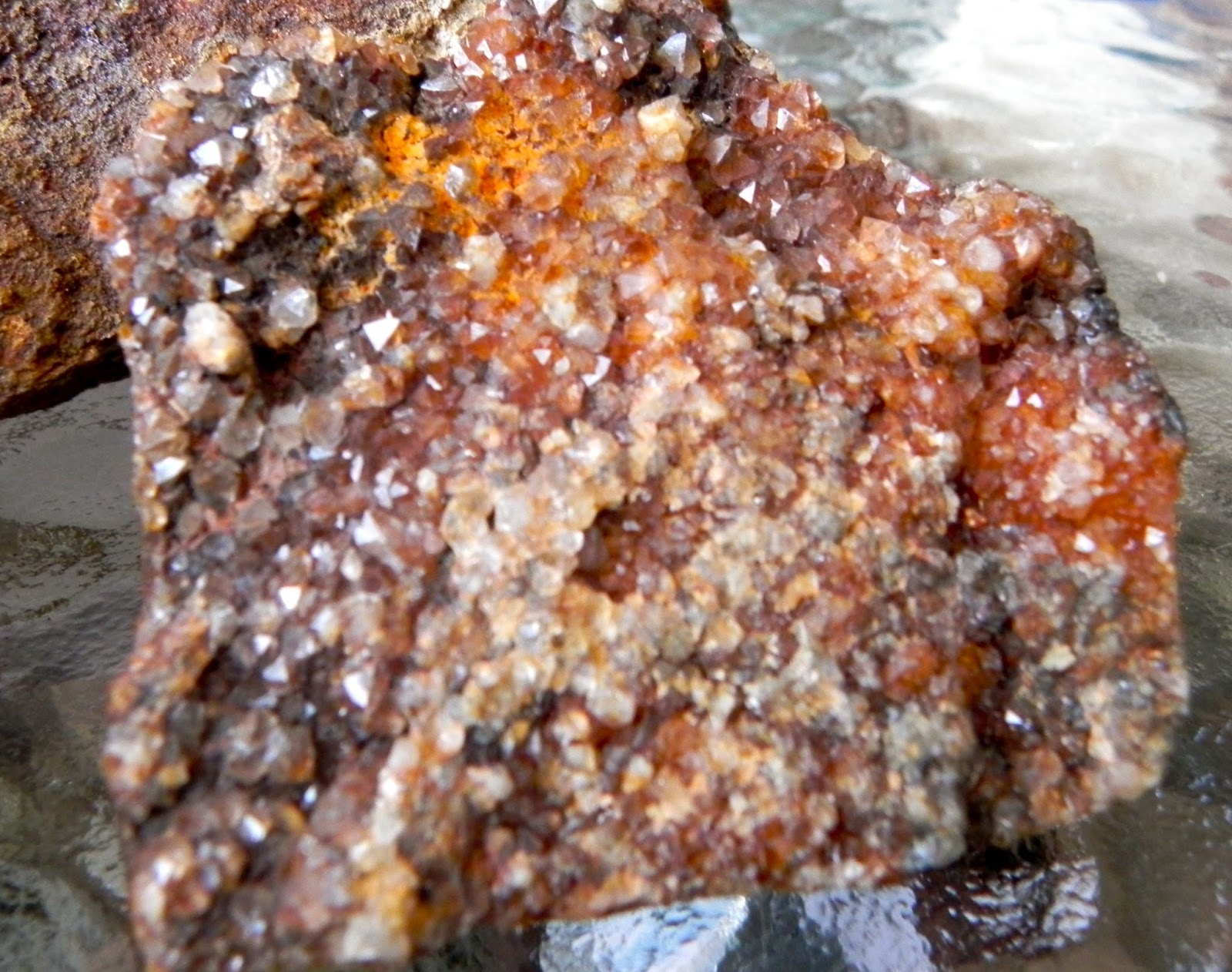
Close-up View of Some of the Tailings
The tailings at the top of the mill site consist mostly of unprocessed ore. At the base of the mill, gravel sized tailings that have been processed through the mill appear to be contaminated with tron, zinc, arsenic, copper and lead. Maybe by processing, maybe just from leaching of the minerals from the ore itself. Whatever the cause, the tailings below appear uninteresting, while the ore above is scattered with visible samples of chalcopyrite, pyrite, azurite, and malachite.

It turned out to be a beautiful day, we came home with a few good ore samples and had a wonderful time.


Some of My Better Finds
Suggested Reading:

Tuesday, July 16, 2013

Salmon Creek Again

 Well, we enjoyed our last trip to Salmon Creek so much, that we just had to go back. We really want to find some of the bigger agates I keep seeing people find. Anyway, the day was gorgeous and we headed out again with a late start (as usual).

I decided we should check a different, less well known area of Salmon Creek, so we headed towards Merchant Road from highway 505. After we crossed the Salmon Creek bridge I noticed that the areas on the south side of the bridge had been clearcut very recently. We decided to stop and check it out, since so much ground was visible.


View Down Logging Road from Highway
We got out and headed down the road and right away discovered small chips of carnelian. I decided to check out all the tree stumps we passed, and sure enough I found this interesting little bit of river polished petrified wood.
Petrified Wood Hiding Near Tree Stumps
As we moved down the road towards the river, we started finding more and more pieces of carnelian in the road, where the rain had worn gullies in the road. I even found some really nice jasper.

View of Road Towards River and Highway
When we noticed how late it was getting, we decided to turn around and head back. Of course I had to check out one more spot where the loggers had made a clearing above the road. This was where I found my 10lb piece of petrified wood. I don't know how I knew to dig it up, but I'm glad I did. It almost looks like a big piece of a tree root. Wish I had a rock saw!
Who Knew This was Petrified Wood?
After heading back to the car, we decided to drive a ways down Merchant Road. Just around the corner was this neat old farmhouse and barn.

Old Farmhouse

Old Barn

All in all, we did pretty well for the day. We got home very late and tired, but the day and the outdoors were both wonderful.

Our Finds For the Day
Here's a closer view...

Close-up View
For further trip reports on this area, view the links below.

Sunday, June 30, 2013

Carbon River Mining District

OK, I just can't take this heat, and neither could my brother visiting from Kodiak AK, so we headed up the road to the Carbon River Mining District in the Mt. Baker Snoqualmie Ranger District near my house. I have been researching this area for quite some time and have found some mines, am still searching for more mines and have found a few really nice rocks up there.

Coplay Lake

We decided to pay a visit to Coplay Lake and check it out. It was nice and cool and peaceful up there. I have found some really nice crystals in this vicinity in the past.


Unknown Brown-Red Crystals
I have read some old reports about the mines in this district and I know that there are some mines near East Lake. I think some of the reports are confused because they place the East Lake mines near the Clipper Mine and the Chicago group near East Lake. I think the East Lake Mines are near East Lake personally. Anyway we drove around the back side of East Lake and low and behold, we found a mine right next to the road. We could tell by the tailings.

My Mt Rainier Climbing Brother on top of the Tailings
We also noticed a strange large pipe in the area, but could not locate the mine opening. It may have been bulldozed by the forest service. 
Unknown Iron Pipe
The pipe seemed to be made of iron and was very thick. It was filled with rocks. We finally figured out the pipe was a well. We didn't find much here except some peacock ore stained rock. Most of the rocks were a reddish colored quartz. 

Closer View of the Tailings
Next we headed to my old favorite, the Clipper Mine. It's an easy 1/4 mile hike to this large hard rock mine. I can usually find a few nice pieces of Malachite, azurite, tourmaline, pyrite and maybe even copper here. It has definitely become a popular place since I posted a YouTube video of it.


We hiked up the old mine road to the mine and poked around here for a while.

Mine Road Crossing Shiplake Creek
You can definitely see signs of past mining in the area.
Old Culvert
There is old cable lying around everywhere, telling me that there was serious mining going on up above. They used the cable to tram the ore down the hills.
Mining Cable
You will know you're in the right spot when you see the BIG pile of tailings on your right.

Huge Tailings Pile
We poked around here for a while and found a few nice rocks. It was a great way to get up away from the heat and also bring back something to show for it.

Some Nice Finds for the Day
Here is a closer view of my son's pyrite find. He claims he hates rock hunting, but he always finds the best rocks. Go figure.
Large Pyrite Specimen
Now, if I could only find the surprise gold mine up above it...
Shiplake Creek

We stopped and took pics of Shiplake Creek next to the road on the way out. It was a wonderful, cool day.

Monday, April 15, 2013

Golden Tunnel Mine New Links

Golden Tunnel Mine Claim Map

Many thanks to Tom A. for sending me this link to a 1901 prospectus for the Durango Boy Mining Company who owned the Golden Tunnel Mine.

Here is the link: http://hdl.handle.net/2027/uc1.31822031028566

And here is the mill site and vein map.
Ore Veins and Mill Site of Golden Tunnel Mine Area

Tuesday, April 2, 2013

The Strange New Mexico Crop Circle? Plus some Fluorite and Smokey Quartz

So, we are planning a trip to New Mexico soon and will probably be going to a family reunion in Ruidoso. So what do I do? I get to work seeing what I can find for rockhounding spots in the area. Right away I find another wilderness study by USGS. Why is it that every time I find a good rock hunting spot, the government has blocked it with a wilderness area? I discovered some of the most beautiful crystals are now closed up in a wilderness area. What a shame.


Sierra Blanca, White Mountain Wilderness, Lincoln Co., New Mexico


Anyway, after realizing that this area is not going to see me, I started looking for nearby areas and as usual I ended up a long way from where I started.

I got to read all about Fort Cummings, Cooke's Spring, Cooke's Peak, and the Butterfield Trail. Pretty interesting actually. I really liked the nearby Peak named Massacre Peak that I noticed on the map.

Fort Cummings
When I read about this stuff, I always check out the USGS map locator and look at the topographic maps of the area and Google Earth. I just love Google Earth. I can look at stuff that I want to see and have even pinpointed petrified logs using it. While looking at the topographic map, I noticed there were mines everywhere near Cooke's Peak. Some info I got from a mine claim for sale said that this mining area had lots of agate, jasper, quartz and petrified wood. Cool! I'm sure there's a USGS report about it. I just haven't found it yet.

Topographic Map Showing the Mines
Apparently there used to be a mining town called Cooke's Town at the bottom of the mountain. Woohoo! A ghost town! I also ran across another report, this one from the Museum of New Mexico discussing The Fluorite Ridge, Fluorspar Mines and I am ready to head out! 

New Mexico Fluorite - Fluorite Ridge


Anyway, while I was scrolling around using Google Earth, I noticed this VERY STRANGE IMAGE. Near the Fort Cummings area. I have no clue. it is not a mountain, It is not a mine, It is flat. It circles through the ground and lava. I'll let you all figure it out. I'm clueless, well not clueless. I might have an idea, but of course it involves the GOVERNMENT. Of course it does!


Strange New Mexico Crop Circle
So much to see, so little time! I'm ready to go now!

North Fork Snoqualmie River

Last Friday was such a beautiful day, and I was off, so I just had to get out. Looking for rocks at this time of year can be difficult due to the snow. But a couple weeks ago I stumbled across a neat Geological Survey Report about the Alpine Lakes Wilderness Area and it made me want to check out the North Fork Snoqualmie area. I figured that the elevation would be low enough for me to get to without snow and it's not a huge distance away. So off I went.

The first part of the North Fork Road was a nice gravel road, but that soon changed the further I went.


North Fork Snoqualmie Road
As soon as I got up the canyon, it turned to mud. Pretty deep mud. But I kept going anyway. Pretty soon my car was covered in mud. I passed quite a few areas where it looked like the road had been washed out and repaired. I stopped to check out the rocks and take some pics on the way.

Small Creek at a Washout - Should Have Looked Closer at the Red Boulder


Unfortunately as I got close to my destination I ran into snow. I was only .2 miles from my target mine, but the snow just got too deep. The canyon that it's in just doesn't get much sun.

The End of the Road
One of the mines I wanted to see was on the other side of the creek, and I noticed that unless I had on waders I would never get across now. It's just too deep.

Lennox Creek
So, I turned around and headed back towards North Bend. I stopped and checked out the North Fork Snoqualmie River for awhile. It too was running pretty fast. 

North Fork Snoqualmie River
I had read a report that there was a mine up above this area that didn't have a road, so they tried floating their ore down the river in barrels. Needless to say a lot of them didn't make it and you can find the ore in the river sometimes. Unfortunately I only found one little rock that has a bright speck of gold on it. I actually picked up the rock because I liked the colors in it, greens and red. I also found a nice piece of serpentinite (I think) for a yard rock.

If You Look Real Hard You Can See the Gold Speck - Hah!
Following a brief stop there I headed on back down the road. After crossing the Sunday Creek Bridge, I noticed a small stream coming down from the hill, so I stopped and got out to look over the rocks. I found a nice piece of pink feldspar (I think) here, and a heavy piece of quartz. 

Small Unnamed Creek
Needless to say, I didn't hit the jackpot here, but I sure got to enjoy the beautiful day, scenery and weather. 
Mt. Si - What a Beautiful View! 
I will definitely be back after the snow melts.


My Finds - Not Sure what they are - But They're Pretty!
9/6/13 Update:

Just took some rocks out my polisher and found that some of these polished really well. What do you think? It's not really jasper, more like sandstone, but it polished nicely to this point. I figured it would break up into pieces...

Kind of looks like Picture Jasper

Friday, February 22, 2013

Kelly Mine New Mexico

I am blessed in that I have two states I can go rockhounding in. Living in Washington gives me access to hundreds of good sites and visiting New Mexico several times a year gives me the freedom to hunt there also.

Back in October 2012, my sister and I paid a visit to our aging parents and decided they needed to get out rockhounding. We decided to visit the ghost town of Kelly, New Mexico where for a fee you can visit the mines and collect rocks.

Kelly is best known for its specimens of Smithsonite and according to the brochure, up to 80 different minerals. It has been greatly picked over, but a lucky hunter can still find some. We got lucky and found little Smithsonite (Zinc carbonate), lots of pyrite and some azurite copper ore. But what made us really lucky was that Bennie Zamora, the owner of Tony's Rock Shop in Magdalena decided she was going to clean out her stock on the day we visited. She literally gave us many great specimens for free!

We first stopped at Tony's in Magdalena to purchase passes to the mine area. It was a wonderful day, not too hot and not too cold. The rock shop has thousands of various rocks just laying everywhere.


Tony's Rock Shop, Magdalena, NM


After our brief stop, we headed on up the road to the ghost town of Kelly and the Kelly mine. The last few hundred feet of the road were horrible. Good thing we had a high clearance vehicle.

Great Sign 

After Arriving at the parking area, we all piled out and started searching the parking area. I found a small tarantula crawling through the weeds.

Small Tarantula in Center of Photo


We could see the old headframe up the hill from the parking area.

Headframe in Far Background


We got out our map and headed up the road.

Map of Kelly Mine and Townsite


Once we reached the top of the hill, we started looking for rocks.

Refractory, Boiler and Assay


The headframe is in remarkable condition, considering it's over 100 years old.

Kelly Mine Headframe

Here is the sign telling about the mine and townsite.

History of Kelly


The sign says, "The town of Kelly New Mexico, which thrived here, was more than a mining boomtown.... it was home to it's thousands of citizens. The mining operations sent huge shipments of lead, zinc, and silver ores to smelters, which helped build America during the industrial westward expansion. These great shipments made Kelly the foremost mine in New Mexico's 19th century past. John S. Hutchason arrived here in 1866 after serving in the Civil War to prospect this area at the invitation of his partner Pete Kinisinger. The early town on this site as called "Middle Camp:, and formed a hub for the Graphic, Waldo, Juanita, and Kelly Mines.

The name Kelly came from Patrick H. Kelley who held a few of the claims. By 1884, Kelly Township was established with banks, churches, saloons, a clinic, and several mercantile stores, while Magdalena was established 3 miles north as the AT & SF Railway terminus to haul away the preciousores from these mines. The last residents of Kelly departed in 1947, and most of their homes were painstakingly hauled down to Magdalena.

The Kelly Mine headframe still proudly stands today as the sentinel of New Mexico's famous mining heritage. This headframe was erected in 1906 by Gustav Billing owner, being purchased from the Traylor Engineering Company of New York, which acquired this headframe in kit form from the Carnegie Steel Works of Passaic New Jersey after it was designed by Alexander G. Eiffel to be the state-of-the-art technology of that era. It stands today as a lasting monument to the men who toiled and sacrificed their brave lives for the prosperity of an emerging nation, towering 121 feet over the Tri-Bullion Shaft which drops nearly 1,000 feet down into a maze of over 30 miles of tunnels, all now closed, silent as the grave."


We had a wonderful afternoon searching the area. We could have spent days there, but had to get home. You must stop at the rock shop on the way out, so they can weigh your rocks and make sure you didn't fall down a shaft. This was when Bennie gave us many of her great rocks. She is a wonderful person. I know I want to visit again in the near future.


Below are some of the great rocks we found and were given by Bennie. All in all it was a great trip. Well worth the time and money.

Chalcedony Rose
A Wonderful Geode
A Neat Crystal
A few of the Better Ones
Great links to info on Kelly and the Kelly Mine: